  |
|
|
|
South
Carolina Coastal Erosion Study |
Geologic Mapping
|
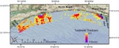
The USGS/South Carolina Sea Grant Consortium Coastal Erosion Study is centered
within Long Bay, a large sediment-starved embayment bound to the north by Cape Fear and associated
shoal complexes, and to the south by Santee Delta/Cape Romaine
(Figure 1). South Carolina's Grand Strand, the focus of this
study, is centered on a 100-km arcuate stretch of coastline within the apex of Long Bay. This
region has few large inlet/fluvial systems and is characterized by a limited influx of modern sediment.
Geophysical surveys, designed to define the geologic framework within the Grand Strand region, were
conducted in 1999 - 2003. The survey area extends from seaward of breaking waves (< 1 km) to ~10 km
offshore, and covers approximately 700 square kilometers of the inner-shelf and lower shoreface
(Figure 1).
High-resolution sidescan-sonar and interferometric bathymetric sonar systems were
utilized to map the surficial sediment distribution and regional bathymetry; seismic-reflection
systems were used to define the underlying geologic structure. Surface grab samples, cores,
video and photographs were collected throughout the region to ground-truth the geophysics.
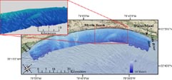
The inner-shelf off South Carolina's Grand Strand has a low-relief, gently dipping seaward slope with
depths ranging from 4 meters in the nearshore to 14 meters offshore
(Figure 2).
 |
| Figure 2.
Bathymetric data collected offshore of Myrtle Beach, SC 1999 - 2003. Depth
ranges from 4 meters in the nearshore, to 14 meters offshore.
Click on image to view larger version.
|
Bathymetric highs are present in several locations throughout the survey area; shoal complexes offshore
of Waites Island and Murrells Inlet, a shore-oblique oblate feature trending NE-SW offshore of Myrtle Beach,
and a ridge complex north of Winyah Bay, proximal to North Inlet. In general, these bathymetric highs
correspond to regions on the inner-shelf that have some ( > 1 meter) accumulation of modern sediment.
The surficial character of the seafloor is somewhat variable within the Grand Strand region
Figure 3). High-resolution sidescan-sonar systems were used
to record the acoustic character of the seafloor. Variations in the strength of the return signal are
represented as gray-scale values within an image; areas of low-backscatter (low-reflectance) are
displayed as dark tones, areas of high-backscatter (high-reflectance) are displayed as light
tones. Offshore of the Grand Strand, surficial grab samples and video show areas of low-backscatter to
be characterized by fine-medium sand, silt, and mud.
 |
| Figure 3. Sidescan-sonar
data collected offshore of Myrtle Beach, SC, 1999
- 2003. High-backscatter is represented by light
tones within the image, low-backscatter is represented
by dark tones. Click on image to view larger version. |
Conversely, areas of high-backscatter are shown to be characterized by coarse sand, shell hash, hardground (outcrop),
and gravel. In general, fine-medium sand, low-backscatter areas correspond to relative bathymetric highs, while
high-backscatter areas dominated by coarse-sand and outcropping older strata correspond to relative bathymetric
lows or areas of constant relief.
 |
| Figure 4.
Sidescan-sonar data collected offshore of Myrtle Beach, SC, 1999 - 2003.
High-backscatter is represented by light tones within the image, low-backscatter
is represented by dark tones. (Figure modified from Baldwin, 2002).
Click on image to view larger version.
|
Boomer and chirp seismic-reflection systems were utilized to map underlying geologic structure offshore
of the Grand Strand (Figure 4). Interpretation
of the seismic records reveals several distinct units: Cretaceous/ Tertiary continental shelf strata influenced
by regional tectonics, showing a gentle dip to the SE, with folding present in the northern portion of the survey
area; a regional unconformity representing the latest marine transgression, or several regressive/transgressive
cycles, marking the upper boundary to the underlying Cretaceous/Tertiary strata; paleochannels associated with
old river systems which incised Cretaceous/Tertiary strata at low-stands of sea level; small paleochannels
lying above the regional unconformity, most likely associated with local drainage of small tidal
creeks/inlets and swales; and a patchy, discontinuous acoustically transparent modern sediment
layer overlying the regional unconformity (Figure 5).
 |
| Figure 5. Chirp
sub-bottom profile offshore of Murrells Inlet. The
seismic profile clearly displays underlying Cretaceous/Tertiary
strata (red), paleochannels (orange), and the regional
unconformity (blue). Also displayed is a shoal complex
associated with Murrells Inlet. Vertical scale is
displayed as two-way travel time in milliseconds
and approximate depth in meters (assuming 1500 meters/second
speed of sound). (Figure modified from Baldwin,
2002).Click on image to view larger version. |
 |
| Figure 6. Map
displaying modern sediment thickness within study
area. Sediment thickness ranges from 0.5 - > 6 meters.
Areas devoid of color represent sediment thickness
less than 0.5 meters. Chirp sub-bottom data were
used to define the modern sediment thickness. (Figure
modified from Baldwin, 2002).
Click on image to view larger version.
|
Regional tectonics, changes in sea-level through time, and modern oceanographic processes have shaped the
character of the inner-shelf offshore of South Carolina's Grand Strand. Geophysical and sample data
reveal the inner-shelf to be comprised of a patchy, discontinuous sand sheet, overlying a regional
transgressive unconformity. Sediment thickness increases to the south
(Figure 6). Large accumulations of sediment generally occur
near inlet systems, and in some areas have been reworked by hydrodynamic processes to form shoal and ridge
complexes. The shore-oblique sand body offshore of Myrtle Beach is an exception
(Figure 7). Current research is focused on defining the origin
of this feature. In areas devoid of modern sediment, or with only a thin veneer of sediment,
Cretaceous/Tertiary units and paleochannel fill outcrop at the seafloor, primarily in large areas to the
north and in troughs between sand ridges throughout the study area. Reworking of these older units by
modern oceanographic processes generates a supply of sediment to this coastal region.
 |
| Figure 7.
Map displaying location of bathymetric high offshore of Myrtle Beach. This oblate feature
lies oblique to the shore off of Myrtle Beach. This feature is roughly 11 km long
and 3 km
wide. Current research is focused on defining the origin of this feature.
Click on image to view larger version.
|
|
|
| |